Avalon Satellite System
In 2009 I joined three of my NUS High School classmates (Vijay Ramakrishnan, Minh Tue Vo and Hao Yi Ong) to form Team Britannia to compete in the Singapore Space Challenge (SSC).
SSC is an annual prestigious national design competition that challenges student teams to design and develop realistic space-related concept projects. The competition is organized by the Singapore Space and Technology Association and sponsored by major aerospace industry firms such as AGI and Dassault. Participants work on a variety of projects and complete theoretical models and design prototypes. Their designs are judged by leaders from the space industry. The first prize is S$10,000, second prize S$5,000 and third prize S$2,000.
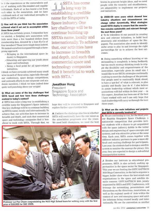
Our innovative design, entitled Avalon Satellite System, won the $10,000 First Prize (US$8,000), beating 21 other teams from engineering departments of various universities and polytechnic institutes. Subsequently, by invitation, two team members (Vijay and Minh Tue) presented this design to many international military and industry leaders at the MilSatCom Asia 2011 conference.
We note that although Avalon Satellite System is only a design concept, it is not science fiction. The Pol-InSAR concept has already been pioneered by the TerraSAR/TanDEM-X project and implemented in other projects by the European Space Agency (ESA) and India. We made sure every instrument used in our system is available from a manufacturer and verified their quoted prices. We also reference numerous existing research papers on the complex process of integrating SAR images and final mapping of surveillance images. In short, our system is practical and cost-effective.
Mission Statement
Over the past century, the strategic location of Singapore has served as a port of call to many ships. Singapore is currently the world’s second-busiest port in terms of shipping tonnage, handles a fifth of the world’s shipping containers and handles half the world’s annual crude oil supply. However, this large volume of shipping activity along the Straits of Malacca and the South China Sea increases the possibilities of accidents, oil spills, and pirate attacks.
A space-based system that is able to monitor the vast sea lanes in the Straits of Malacca and other areas within 400 nautical miles of Singapore would tremendously improve the quality and safety of maritime navigation. The system should provide imaging and 24-hour tracking capabilities for all ships equipped with Emergency Position Indicating Radio Beacons. A Low Earth Orbit (LEO) is the ideal orbit for such a satellite system.
Mission Objective
- Design and launch a satellite or a system of satellites into Low Earth Orbit (LEO).
- The aim of the satellite(s) is to monitor the seaways around Singapore and the neighboring countries.
- The satellite(s) should also pick up distress signals to assist search & rescue operations (SAR) and monitor pirate activities around the region.
Mission Specifications
- The total weight of the satellite(s) must not exceed 2000 kg.
- The lifespan of the satellite(s) has to exceed 5 years.
- The cost of designing and maintaining the satellite(s) must not exceed S$300 million over a period of 5 years.
- The satellite(s) must have sufficient imaging capabilities to pick up speed boats used by pirates.
- The respond time of the satellite(s) should be less than 20 minutes upon activation of an emergency transmitter.
- The satellite(s) has to be compatible with and able to derive tracking information from Cospas-Sarsat 406 MHz digital type transmitters and the 3 types of distress radio beacons: Emergency Position-Indicating Radio Beacons (EPIRB), Emergency Locator Transmitters (ELT) and Personal Locator Beacons (PLB).
- The satellite(s) has to provide near real time downlink of imaging data to the Singapore Global Maritime Distress & Safety System (GMDSS) monitoring station.
Our Solution
System at a Glance
- One main satellite and two microsatellites in interferometric cartwheel formation.
- Altitude: Low Earth Orbit (600km equatorial orbit).
- Period: 51 minutes (28 overflights per day).
- Total effective coverage over Singapore: 100 minutes per 24-hour period.
- Total injected mass: 1070 kg.
- Payload: SAR transmitter/receivers, AIS receiver and 406MHz receiver.
- Imaging capability: single-pass Polarimetric-Interferometric Synthetic Aperture Radar (Pol-InSAR).
- Maximum resolution: 1 meter.
- Power: solar arrays.
- Worse-case response time: 15 minutes.
- Propulsion: diverging cusped-field Hall-effect thruster.
- Launch: Arianespace‘s Soyuz launch vehicle from the Guiana Space Centre in French Guiana.
- Lifetime cost: S$286 million.
Video Demonstration
The following video demonstrates the launch sequence, orbit insertion, formation flying, ground communication, intersatellite communication, and three different imaging modes of our system. This simulation was created in AGI’s STK 8.0 software, the industry standard for designing real-world satellite missions.
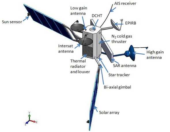
Main Satellite
- Mass: 858kg
- Payload: active dual polarized phased-array SAR transmitter, receiver for AIS transponder and receiver for 406MHz distress beacon.
Below is a diagram from a 3D model of the satellite made in 3ds Max.
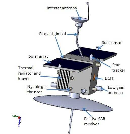
Microsatellite
- Mass: 106kg
- Payload: passive dual polarized SAR receiver.
Below is a diagram from a 3D model of the satellite made in 3ds Max.
Technical Concepts
Synthetic Aperture Radar (SAR)
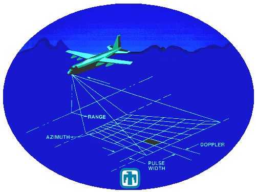
Synthetic aperture radar (SAR) is a coherent side-looking radar system which uses its motion relative to the ground to build a large effective aperture that is impractical for a stationary radar system. For remote sensing applications (such as ours), the motion is created by mounting a transmitter on a moving platform, for example, a satellite.
SAR uses an echo’s time-of-flight to determine the range (or cross-track) to the target. The longer a pulse takes to reflect back, the longer the distance to that target. SAR uses the Doppler shift of an echo to determine the azimuth (or along-track) information. A shift to higher frequency in the reflected pulse means the target is approaching the radar’s beam and vice versa.
The defining advantage of SAR over static radars is the ability to create a large effective synthetic aperture by flying over a distance of the effective aperture while simultaneously receiving echoes from the target.
SAR radars can scan wide swaths and spot small targets quickly, perfect for ship detection. Ship detection using SAR relies on the intensity of the back-scattered radar waves. Because the material of a ship surface is rougher than that of the sea surface, the ship surface has greater diffuse reflection and will appear “brighter” than the sea surface in a typical SAR image.
Because cloud cover happens frequently in tropical Singapore, an SAR system (which can easily penetrates clouds by transmitting at microwave frequencies) is the only all-weather and all-lightning observation solution.
However, during rough seas, ship detection by only SAR becomes a problem because the sea surface also becomes rough, leading to false detection of ships. SAR images also contain no information about elevation.
Polarimetric-Interferometric SAR (Pol-InSAR)
Pol-InSAR (Polarimetric-Interferometric SAR) allows us to simultaneously determine textural properties (from polarimetry) and spatial properties (from interferometry).
- SAR polarimetry enhances the resolution of SAR radar images and complements the wide-swath scanning capability of SAR. Polarization is the orientation of the electric field vector in an electromagnetic wave. An object’s microwave reflectivity depends on the relationship between the polarization state and the geometric structure of the object. Although the polarization in back-scattered electromagnetic waves from a ship carry vital information about surface texture, target-orientation, shape, symmetries and so on, this information will not be picked up by the aforementioned “amplitude-only” SAR system. Polarimetry enables ship detection even during rough sea conditions because the inherent back-scattering properties of a ship and the sea are different.
- SAR interferometry is the use of the phase difference of two received radar echoes of a single target at different positions to determine the target’s height information, known as Digital Elevation Map (DEM) interferograms. This technique can detect height differences in the terrain to within a few meters and enables ship classification i.e. the identification of the physical properties of a ship like its size and shape. Ship classification using only SAR polarimetry is not possible because a ship’s geometry cannot be accurately determine with a polarimetric-only system.
Repeat-Pass vs Single-Pass Pol-InSAR: the Interferometric Cartwheel
A single-satellite SAR interferometry system can create a Digital Elevation Map (DEM) interferogram by analyzing the phase difference of two received radar echoes of a single target at different satellite positions. If the target is stationary, the satellite gets the first echo from the target on the first pass, notes the phase of the echo and revolves around the Earth until it can get the phase of the second echo on the second pass from a different position. The phase difference gives the height information. This is called the repeat-pass mode which is used by most conventional SAR systems.
However, repeat-pass mode will not work for moving targets, such as pirate boats, because by the time the satellite comes around for the second pass, the targets most likely have already moved to a different position. This difficulty necessitates a single-pass system.
In a single-pass system, instead of orbiting around the Earth to get the phase of the second radar echo, two additional receiving satellites are used in addition to the main transmitting satellite. These receiving satellites are positioned at predetermined locations around the transmitting satellite. Because the receiving satellites are at different locations, they will immediately calculate the phase difference of echoes from a target and eliminate the hassle of making a second pass.
The interferometric cartwheel is a special configuration for a satellite system in which one receiving satellite appears to rotate around the other receiving satellite. This configuration create sufficient baseline distances for along-track (to detect motion) and cross-track (to map terrain elevation) interferometry throughout the whole orbit.
More Details
If you want to learn more about our design (such as the communication, propulsion, power, thermal subsystems; the cost analysis or our extensive trade studies), please read our 100-page detailed technical report.
Media Coverage
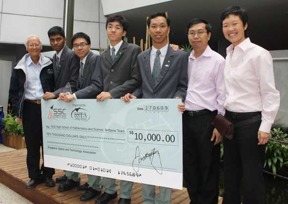
Award Ceremony
The award ceremony of the Singapore Space Challenge 2009. From left: Prof. Lui Pao Chuen (advisor, National Research Foundation), Vijay Ramakrishnan (team member), Minh Tue Vo Thanh (team member), Hao Yi Ong (team member), Huy Nguyen (team member), Mr. Wong Chee Long (teacher-advisor) and Ms Lim Hui Wen (vice principal).
Media Coverage by the trade magazine Aerospace Singapore
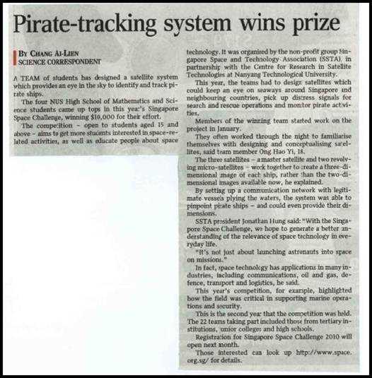
Media Coverage by the national newspaper Straits Times
Click here for a transcript of the Straits Times newspaper article.
Where They Are Now
It was my great privilege to work alongside very brilliant and dedicated team members in this competition.
After this competition, Hao Yi again teamed up with me in the Singapore Statistical Poster Competition. He graduated with High Distinction from NUS High School and received both a bachelor’s and master’s degrees in mechanical engineering from Stanford. He’s currently a research scientist at Lyft in San Francisco.
Minh Tue won numerous awards during his high school career, including two gold medals in the Singapore’s National Olympiad in Informatics, two gold medals in the Singapore Mathematical Olympiad, the championship in the Singapore Physics Olympiad and many journal publications and presentations at international conferences. He graduated with High Distinction from NUS High School and subsequently received a bachelor’s degree in computer science from MIT while earning himself a US patent in the process. He is currently a machine learning engineer at Cisco in San Francisco.
Vijay won a gold medal at the Singapore Science & Engineering Fair 2009 for his research on the cancer gene p53 and presented this work at the Ritsumeikan Science Fair 2010 in Japan. He graduated with High Distinction from NUS High School and received a bachelor’s degree in computer science from Harvey Mudd College. He’s currently a machine learning engineer at Cisco in San Francisco. In fact, he and Minh Tue are teammates now. Small world indeed!
